
Real world, what would happen if A-10s arrived at night to an airfield like Gudauta with no TAC or ILS? Assuming they would be permitted to land, what would be the real world procedure?


Real world, what would happen if A-10s arrived at night to an airfield like Gudauta with no TAC or ILS? Assuming they would be permitted to land, what would be the real world procedure?
ZULU

Tactical browning of the underpants is first on the checklist!
There are sever different types of approaches that can be made besides TCH and Ils. At night with no lights they would use goggles. Not sure what type of avionics the new A-10's have but an GPS approach would be a great option if it is available.
Last edited by Ashy; 15May15 at 23:23.
Adapt.... Improvise.... And Overcome....
[SIGPIC][/SIGPIC]
When you say "no lights", are you referring to the airfield's lighting? I'm working with the assumption that the airfield is lit. Just a point of clarity, not challenging your response.
Plenty of FAA manuals on the topic.
So the FAA docs define the behavior of all aircraft in this scenario, including military? I probably have an incorrect "civil" notion of the FAA, then.
Maybe I'm not understanding your question, the FAA is the governing body. Some things don't apply but I think for what you're asking it does. If not hopefully Noodle will clarify.
Page 4-57, Visual Approaches (here)
Last edited by Snoopy; 15May15 at 23:35.
Not To entirely sure what the military does. And for some odd reason I thought you had said no lights. And that's why I said they use googles. Totally mis read that. But besides that. Yea I'm talking about airfield lighting. Tower basically turns all the lights off and then they will practice approaches. And I'm not sure if the faa governs that. And I don't think they care as long as it done with in minimums. If you want to learn more or rules and regs Google Far/aim. But keep in mind that is only for the United States. Different countries have different regs. And be prepared to read lawyer written jargon.
Adapt.... Improvise.... And Overcome....
[SIGPIC][/SIGPIC]
Assuming it's visual meteorological conditions (VMC), you can simply fly a visual approach. Visual approaches are wonderful things, and are generally preferred by all parties. ATC gets to pawn off responsibilty for separation between aircraft to the pilot(s); the pilot's don't have to fly arcs/procedure turns or fly long finals; airport capacity (arrival rate) is increased because of the reduced separation required; and it reduces workload during a high workload phase of flight.Originally Posted by Dojo

If the weather is marginal but still VMC, you generally receive radar vectors to a point at which you would be able to acquire the airport visually. Once you report the field in sight, you'd be cleared for a visual approach.
If the weather is instrument meteorological conditions (IMC), you could receive vectors to a ground controlled approach (GCA) or a precision approach radar (PAR) approach. Both are "talk-down" type approaches, with the PAR having minimums roughly equivalent to a CAT II ILS approach. These approaches don't require any onboard navigation equipment. There's some small print here, but its beyond the scope of what we're talking about.
The A-10 can't legally do this - although it has the capability - but there are things called self-contained approaches. They're predicated on having and using the aircraft's radar - called an Airborne Radar Approach (ARA) - or using a 3D navigation to a GPS or INS waypoint, sometimes called a Self-Contained Navigation System (SCNS pronounced "skins") approach.
Other than that, without TACAN/VOR/ILS/NDB/etc., you're going to the alternate.
Hope that wasn't useless.
Da FAC?

In his book "Viper pilot", Dan Hampton describes a situation where they have to land at Ali al-Salem, that has no IFV charts.
It's night. There's a sandstorm, with only a quarter mile visibility. There's 10 of them.
He flies to the airport, get's a markpoint on the beginning of the runway and communicates the L/L and elevation with all the others.
That point they use to get themselves on the ground.
Something like that can be done in DCS.
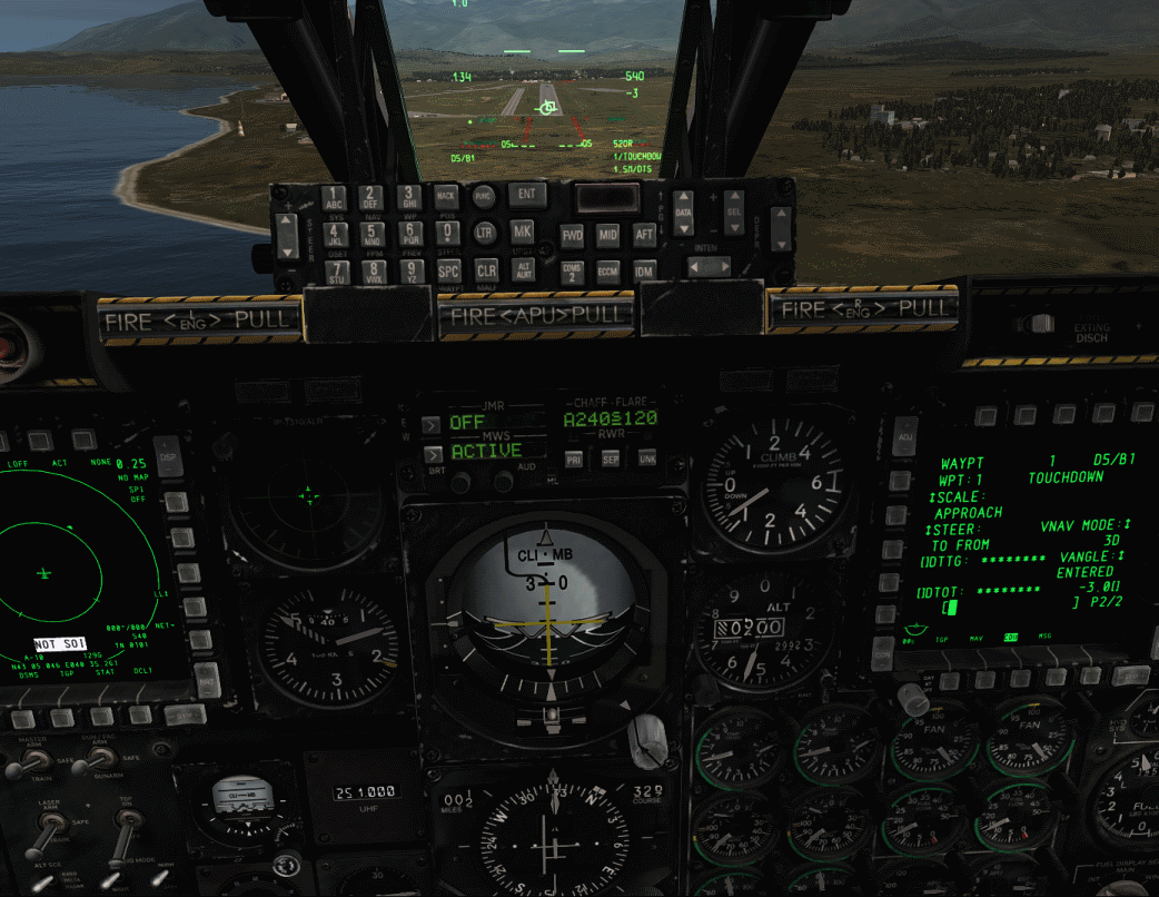
Get yourself a markpoint of the beginning of the ruwnway.
You make a mission waypoint out of that markpoint with following settings:
SCALE: APPROACH
VNAV MODE: 3D
VANGEL: ENTERED
value for VANGLE: -3.0 ("glideslope" angle)
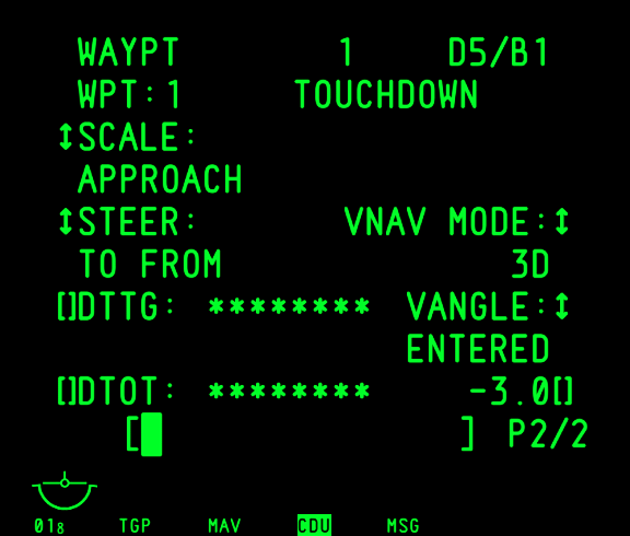
You can use that waypoint as a steerpoint to get yourself on the ground.
Just verified it. Works like a charm.
So, you have that going for you if there are no other options available.
Providing CAS when you're all out of HUA!
 Posting Permissions

You can help us by donating to cover our costs.
Many sincere thanks!
![]()
![]()
![]()

 Reply With Quote


